Summary information
GPS coordinates: 32.62245, 35.79571
Structure is somewhat visible in Google maps.
The building, preserved only at the level of the foundations, was a basilica with three naves (25.60 x 12.50 m) ending in a projecting central apse flanked by two inscribed side apses, slightly recessed.
To the west, it was entered from a vestibule (12.00 x 3.90 m) by three doors opening onto the three naves of the church, which were subdivided by two rows of six square pillars (0.75 m sideways). The pilasters (0.30 x 0.70 m) attached to the walls north and south of the church in alignment with these pillars indicate presumably a transverse subdivision of the aisles by arcades, which could support a covering with stone slabs.
To the south, a door opened onto a side chapel (6.50 x 16.00 m approximately) whose eastern end had disappeared, but where the subdivision by a chancel screen was still visible. The building was belatedly transformed into mosque by adding a mihrab to the south wall.
The chancel, raised 0.25 m above in the nave, extended at least to the apse and to the last two spans of the central nave; its outline cannot be specified for the aisles.
The whole building was paved with mosaic, whose remains were very fragmentary. Near the sanctuary remained a pattern of intertwined circles and two very incomplete inscriptions – one in Greek, the other in Aramaic-Christo-Palestinian, placed next to a fragment depicting an amphora or a kantharos. The carpet of the nave, surrounded by a double border of meanders and braids, decomposed into a network of intertwined scutae determining octagon patterns.
In the northern aisle appeared a network of octagons laden with human and animal figures. surrounded a border of foliage inhabited by various mammals.
The pavement of the southern room, oriented north-south, featured a pattern of intertwined circles defining rectangles every four circles. The animal figures of the pavement were mutilated then repaired with large tesserae, at least in the aisles and in the room to the southwest of the church.
Anne Michel, Les Eglises d’Epoque Byzantine et Umayyade de La Jordanie V-VIII Siecle (Turnhout: Brepols, 2001), 137–38.
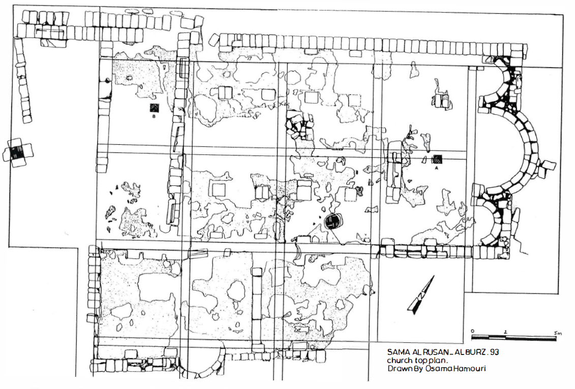
The stratigraphy, considerably disturbed by the agricultural work and the holes dug by looters, no longer made it possible to propose a dating for the building of the church. According to the stylistic analysis of mosaic floors, the excavators located the erection of the building approximately in the 6th century. The building was used beyond the period that saw the mutilation representations figured on the mosaics, subsequently repaired using large tesserae, but it is not possible to specify whether it was still used as a Christian building: the southern chapel was apparently transformed into a mosque during the Umayyad era, as tends to indicate it the typology of the ceramic which was picked up there.
Anne Michel, Les Eglises d’Epoque Byzantine et Umayyade de La Jordanie V-VIII Siecle (Turnhout: Brepols, 2001), 138.
Khasawneh, N. “Final Report on the Khirbat Al-Burz – Suma Ar-Rusan Excavation تقرير نهائي عن حفرية خربة البرز- سما الروسان.” Annual of the Department of Antiquities of Jordan Arabic 38 (1994): 21–30.
Michel, Anne. Les Eglises d’Epoque Byzantine et Umayyade de La Jordanie V-VIII Siecle. Turnhout: Brepols, 2001.
Characteristics
- Tri-apsidal with side apses inscribed
- Π-shaped chancel (aisles uncertain)
- None
- The whole building was paved with mosaic, whose remains were very fragmentary. Near the sanctuary remained a pattern of intertwined circles and two very incomplete inscriptions – one in Greek, the other in Aramaic-Christo-Palestinian, placed next to a fragment depicting an amphora or a kantharos. The carpet of the nave, surrounded by a double border of meanders and braids, decomposed into a network of intertwined scutae determining octagon patterns.
- In the northern aisle appeared a network of octagons laden with human and animal figures. surrounded a border of foliage inhabited by various mammals.
- The pavement of the southern room, oriented north-south, featured a pattern of intertwined circles defining rectangles every four circles. The animal figures of the pavement were mutilated then repaired with large tesserae, at least in the aisles and in the room to the southwest of the church.
- Three west entrances
- South entrance from side chapels
- Attached south chapel to the west
- None
Constantinopolitan
- Protruding apse
- Entrances from the east on either side of the apse
- Π-shaped chancel
- Multiple entrances on all sides
- Ambo on the south
- Exterior chapel to the north
Syrian
- Π-shaped chancel
- Inscribed mono-apsidal
- Room on both sides of the apse
- West entrance
- Ambo on south
- Baptistry in room south of the apse or in the south aisle
- Separate south chapel
- South entrances from side rooms/chapels
Roman
- Τ-shaped or bar-shaped chancel
- Tri-apsidal usually inscribed
- Altars in the side apses
- Relics and Reliquaries
- Ambo to the north
- Baptistry outside off the atrium or the north aisle
- Marble furnishings (high status imperial association) and imported fine wares
- Decorative elements on chancel screens [specify]
- Separate north chapel
Syrian to Roman conversion
- Τ-shaped or bar-shaped chancel replacing Π-shaped chancel
- Side apses inserted into rooms adjacent to the main apse
- Separate north chapel (suppressed south chapel)
- Liturgical furniture with decorative motifs like those at St. Clemente in Rome
Classification
Mostly Roman, but chapel to south (Syrian?)
Roman
Τ-shaped or bar-shaped chancelΠ-shaped chancel- Tri-apsidal usually inscribed partially
Altars in the side apsesRelics and ReliquariesAmbo to the northBaptistry outside off the atrium or the north aisleMarble furnishings (high status imperial association) and imported fine waresDecorative elements on chancel screens [specify]- Separate
north[south] chapel
The Archaeology of Liturgy Project reflects research conducted at the W.F. Albright Institute of Archaeological Research in Jerusalem during 2023.